Showing posts with label RF Coverage. Show all posts

Compile SPLAT! RF coverage software on 64-bit Windows

 Posted by:   Posted on:    5 comments

SPLAT! is a cross-platform, open-source software that can be used to analyse a radio link between two locations and to generate coverage maps of RF transmitters. Coverage maps are calculated using Longley-Rice Irregular Terrain Model (ITM) algorithm. SPLAT! can predict RF coverage for any frequencies between 20 MHz and 20 GHz. It is thus useful for ham radio, broadcast radio, terrestrial television and wireless networks. Although it is cross-platform, up-to-date binaries for Windows are hard to find. On the other hand, for Linux users, it is available in the repositories of the major distributions.

I wrote in a previous post about SPLAT! and how to compile it with MinGW. At that time, the compiler package I used was only available for 32-bit architecture. Since most systems are now 64-bit, I had to use a different compiler package to get 64-bit SPLAT! binaries. Here is the good news: you can either follow this tutorial or you can jump to the end of this post and grab the precompiled binaries (SPLAT! is licensed under GPL v2).

Compile SPLAT! RF coverage software on 64-bit Windows

Generate radio coverage maps with SPLAT!

 Posted by:   Posted on:    No comments

SPLAT! is a cross-platform, open-source software that can be used to analyze a radio link between two locations and to generate coverage maps of RF transmitters. Coverage maps are calculated using Longley-Rice Irregular Terrain Model (ITM) algorithm. SPLAT! can predict RF coverage for any frequencies between 20 MHz and 20 GHz. It is thus useful for ham radio, broadcast radio, terrestrial television and wireless networks.

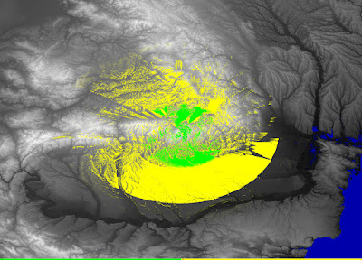
To use SPLAT!, you need to know some parameters of the transmitter. These are the exact location (coordinates), antenna height, transmission frequency, polarization and effective radiated power (ERP). SPLAT! can then compute coverage maps. The procedure of installing SPLAT! is described in a previous article. You can generate two kind of maps. There is the regional coverage analysis mode that will output line-of-sight coverage map assuming all waves propagate in a straight line. There is also the path loss analysis mode that uses the ITM algorithm to compute either a field strength map or a received signal strength map.

Radio link analysis using SPLAT!

 Posted by:   Posted on:    No comments
SPLAT! is a cross-platform, open-source software that can be used to analyze a radio link between two locations and to generate coverage maps of RF transmitters. Coverage maps are calculated using Longley-Rice Irregular Terrain Model (ITM) algorithm. SPLAT! can predict RF coverage for any frequencies between 20 MHz and 20 GHz. It is thus useful for ham radio, broadcast radio, terrestrial television and wireless networks.

To use SPLAT!, you need to know some parameters of the transmitter. These are the exact location (coordinates), antenna height, transmission frequency, polarization and effective radiated power (ERP). SPLAT! can then calculate both path loss and received signal strength.

The procedure of installing SPLAT! is described in a previous article. The point-to-point analysis calculates some useful parameters like: azimuth and elevation of receiving antenna, distance to transmitter, mode of propagation, received signal strength and density. You must also supply a receiver parameters file to SPLAT!. This will contain the location, antenna height and some other terrain parameters. SPLAT! will generate a report and a graph if you have Gnuplot installed.

SPLAT! height profile graph

Compile and setup RF coverage prediction software SPLAT!

 Posted by:   Posted on:    13 comments
SPLAT! is a cross-platform, open-source software that can be used to analyze a radio link between two locations and to generate coverage maps of RF transmitters. Coverage maps are calculated using Longley-Rice Irregular Terrain Model (ITM) algorithm. SPLAT! can predict RF coverage for any frequencies between 20 MHz and 20 GHz. It is thus useful for ham radio, broadcast radio, terrestrial television and wireless networks.

SPLAT! uses data from SRTM elevation files. Although it is cross-platform, up-to-date binaries for Windows are hard to find. On the other hand, for Linux users, it is available in the repositories of the major distributions. This post will show you how to compile SPLAT! on Windows and Linux, how to obtain and convert elevation data and at last how to generate point-to-point and coverage prediction analysis.

There are two variants of SPLAT! based on the type of elevation data they use. SRTM3 files are 90 meters resolution, 3 arc-sec files. These are the "standard definition" files suitable for SPLAT! And there are SRTM1, 30 meters resolution, 1 arc-sec files that are considered "high definition" and are suitable for SPLAT! HD. I recommend SRTM3 (SD) files because the results are very good and processing time is not too high.

SPLAT! line-of-sight coverage